BeamNG.Earth is a mod for BeamNG.Drive which lets you drive real roads anywhere on earth. It's a fantastic mod and slightly dangerous for anyone who likes driving round Wellington at an unreasonable speed. What it doesn't do is tell you afterwards where you went. I wanted a log of my drives, a map to look at them on, and ideally a way to watch the car move around that map while I was driving.
So I built one. It is called ThrashDash. It started life as a set of dashboards for a second monitor or a phone, and the trip log has since become the main reason it exists.
What it does
- Records trips automatically. A trip starts when the car moves and ends when you park for a couple of minutes (you can change this), teleport, swap vehicles or leave the level. It is written to disk as you drive, so a crash loses nothing.
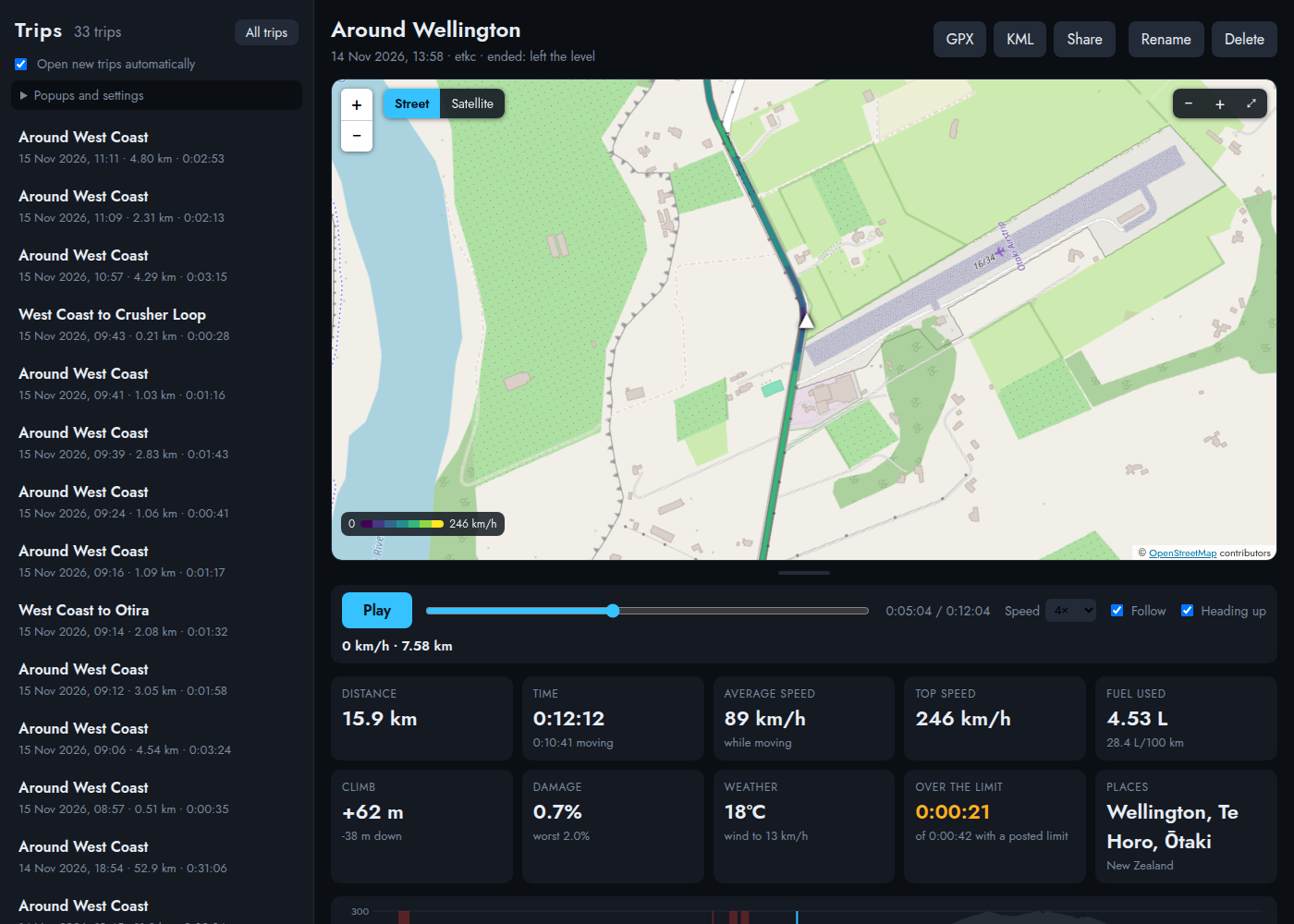
- Names and summarises each trip. You get something like "Courtenay Place to Hutt Road", plus distance, time, top speed, fuel used, climb, weather and the towns and countries you passed through.
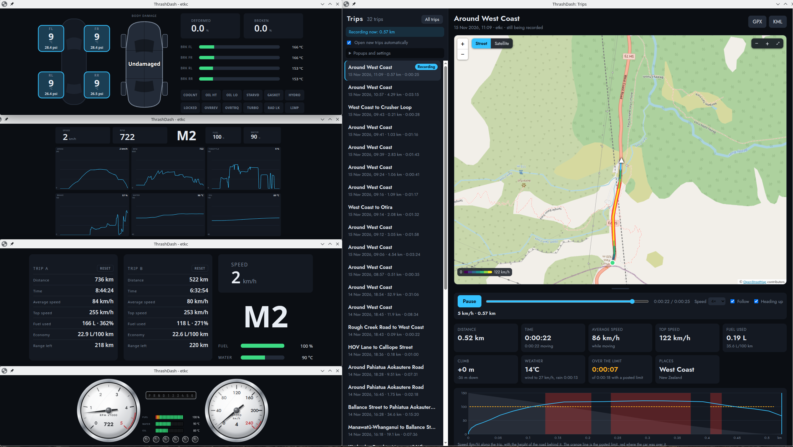
- Shows trips on a map. The route is coloured by speed, on a street or satellite map, with a speed and height graph underneath. You can replay a trip and speed it up, and there is a "heading up" mode where the map turns around the car like a proper satnav.
- Follows the car live. New trips open on the map by themselves. The car marker keeps up with the in-game minimap.
- Shows all your trips on one map, so the roads you drive most are brightest. One of mine is in Louisiana, which I didn't expect to see when I filtered by country.
- Exports trips. GPX, KML (the web version of Google Earth shows it fine), or a single .html file you can send to someone who has nothing installed.
- Pops up a message in the game when a trip ends.
- Still does dashboards. There is a drag and drop editor, ten ready-made dashboards, gauges, tyres, damage and trip meters. A phone, tablet, or other device on your network can show them too, behind a PIN.
Everything runs on your own computer. There are no accounts and nothing is uploaded. The only thing that touches the internet is the map pictures.
How it works
Two small Lua pieces sit inside BeamNG. One sends the car's data and the other asks BeamNG.Earth where the car is. They send UDP packets to 127.0.0.1. A small Python program catches them, writes the trips to disk and serves the pages. You look at it all in an ordinary browser window next to the game. The pages are plain JavaScript with no build step.
Installing it
Linux
Grab the AppImage from the releases page, then:
chmod +x ThrashDash-0.1.0-x86_64.AppImage
./ThrashDash-0.1.0-x86_64.AppImage --install-mod
./ThrashDash-0.1.0-x86_64.AppImage
The --install-mod step puts the mod in BeamNG's user folder. Restart the game and respawn your car, as BeamNG only loads the vehicle part when a car is spawned. The trip log needs BeamNG.Earth installed and its level loaded.
Windows
There is a Windows zip too. I have run it on one Windows 11 machine and it worked, but it has had far less use than the Linux build. Windows does ask about network access if you switch on the phone option so be prepared to allow it.
Things that tripped me up
- OpenStreetMap blocked me. My first map came up in three panels all saying "Access blocked". OpenStreetMap refuses tile requests with no Referer, and ThrashDash didn't send one. The Trips page now sends just the origin and nothing else.
- Speeding is mostly a guess. BeamNG.Earth gives a speed limit for nearly every road, but only about one in ten is a real posted limit. The rest are guessed from the road type. ThrashDash only counts time over the limit where the limit is posted, and tells you how much of the trip that covered.
- Wayland won't let programs place their own windows. I use KDE on Wayland. There is an option to run the windows through XWayland, and then each window moves itself to where it was last time. It is off by default because XWayland can look odd on scaled displays.
A word on how it was built
Much like the service desk migration, I couldn't have done this in the spare time I have without AI doing the base work. I came up with the ideas, worked through planning and finalised all decisions, tested it, drove it and told AI what was wrong. I played manager here.
Limits
- Satellite imagery is blurry up close, about 10 metres a pixel. Use the street map for anything detailed.
- Peak G isn't recorded. The position arrives once a second, which is too coarse to catch it.
- The map needs the internet. The route and figures work without it.
I'm pretty pleased with how it has turned out. It is MIT licensed, and the README covers the rest.
Github page: https://github.com/thrashcardiom/thrashdash
Releases: https://github.com/thrashcardiom/thrashdash/releases
That's it!
Post your comment
You cannot post comments until you have logged in, and have an appropriate permission level. Login Here.
Comments
No one has commented on this page yet.
RSS feed for comments on this page | RSS feed for all comments